From sandy beaches to snow-capped mountains to deserts, California has it all. With its natural beauty and fourth-largest economy in the world, it isn’t surprising that the Golden State has some of the most sought-after and most expensive real estate in the United States.
Despite all that makes California a desirable place to live, an underlying threat makes its presence known every year in the form of California wildfires. In 2025 alone, there have been more than 7,855 wildfires, over 525,208 acres burned, and 16,512 structures destroyed. Here, we investigate which California counties are the most susceptible to fires and provide important information to keep your family and home safe.
When is California’s “Fire Season”?
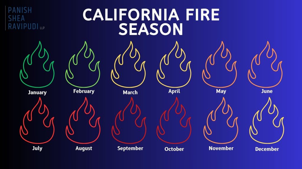
As explained by the Western Fire Chiefs Association, in California, fires can technically happen year-round, but peak fire season varies by region. In Northern California, it typically starts in June or July and lasts through late October or November. Whereas in Southern California, the peak season begins earlier, in late spring, and can continue through October.
Unfortunately, due to rising temperatures and limited rainfall, these destructive firestorms are becoming more and more frequent, with California heading towards a year-round fire season, as we recently saw with the devastating wildfires in Los Angeles County in January 2025.
What are the Primary Causes of California Wildfires?
Although California’s fire seasons are becoming longer and more intense with each passing year, not all fires start the same way. For the most part, these include:
Environmental Factors
California wildfires are a recurring and complex phenomenon driven by a combination of environmental factors that create conditions ripe for ignition and rapid spread. These fires are influenced by a perfect storm of unstable climate, vegetation, and weather patterns such as:
- Drought Conditions: Extended periods of little to no rainfall dry out vegetation, creating easy fuel for fires.
- High Temperatures: Intense heat dries soil and plant life, increasing fire susceptibility.
- Low Humidity: Dry air accelerates the drying of plants and trees, making them more flammable.
- Strong Winds (e.g., Santa Ana and Diablo winds): Can knock down power lines and quickly spread flames across large areas.
- Lightning Strikes: Dry thunderstorms, especially in mountainous or forested regions, can ignite fires without rain.
- Dead Vegetation: Fallen leaves, dry brush, and dead trees create dense fuel loads if not cleared regularly.
- Climate Change: Warmer temperatures, shifting precipitation patterns, and earlier snowmelt contribute to drier, longer fire seasons.
- Invasive Plant Species: Non-native grasses and shrubs can dry out quickly and catch fire more easily than native plants.
- Tree Mortality from Pests (e.g., bark beetles): Insect infestations kill millions of trees, adding to combustible material.
- Lack of Natural Fire Cycles: Fire suppression prevents natural low-intensity fires, allowing flammable materials to build up over time.
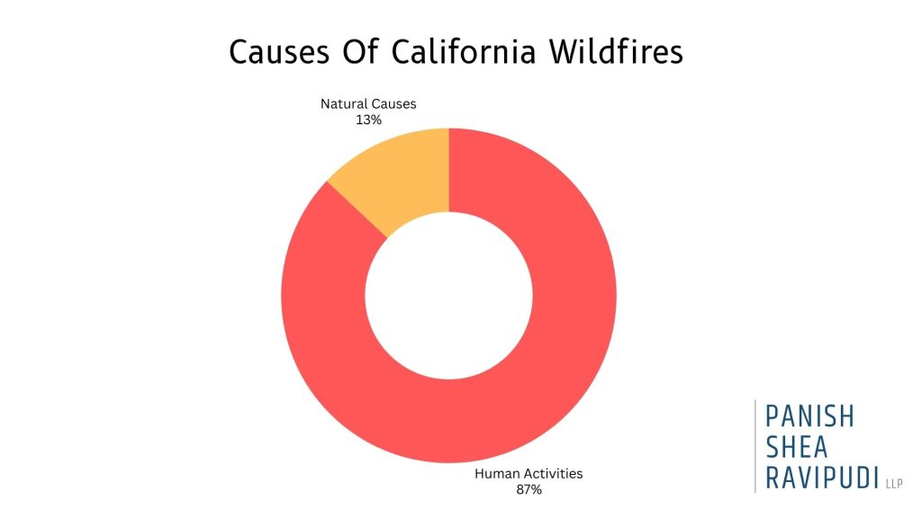
Human-Related Causes
Human activities, including campfires, power line failures, and equipment use, are responsible for approximately 85% of wildfires. The combination of these ignition sources with dry conditions leads to more frequent and severe fires. Some other causes include:
- Power Lines: Electrical equipment malfunctions or downed power lines, especially in areas that have not been properly maintained, can spark fires, especially during high winds.
- Campfires and Outdoor Burning: Unattended or improperly extinguished campfires, bonfires, or debris burning can ignite dry vegetation.
- Arson: Intentional setting of fires by individuals is a significant and criminal source of wildfires.
- Vehicle-Related Sparks: Sparks from cars, trucks, or trailers.
- Cigarettes: Lit cigarettes are tossed from vehicles or while walking through dry areas.
- Fireworks: Illegal or careless use of fireworks, especially around holidays like July 4th, often leads to accidental fires.
- Agricultural Burns and Land Clearing: Controlled burns that get out of control can lead to widespread wildfires.
Target Shooting and Explosives: Shooting in dry, brushy areas or using explosive targets. - Improper Waste Disposal: Dumping hot coals, ashes, or flammable materials in flammable areas.
Ultimately, when various environmental conditions and other causes align, the result is catastrophic fires that grow with immense power and speed, and are often impossible to control or contain until they have run their course.
California Fires Are Getting Worse
Due to California’s geography and climate, wildfires are not a new phenomenon and would occur regardless of the existence of humans. Yet in recent years, there has been a significant increase in the regularity of record-breaking fires in terms of overall destruction, frequency, and size.
- Between 1973 and 2024, the western U.S. saw an average increase of 37 extra “fire weather” days each year, typically marked by high heat, low humidity, and strong winds. This trend is especially severe in California, where these dangerous conditions now happen more often, turning what was once a seasonal threat into a year-round fire risk.
- In January 2025, Southern California was hit by a string of intense wildfires, including the massive Palisades and Eaton Fires. Together, these blazes destroyed more than 18,000 buildings, took 30 lives, and displaced over 200,000 residents. The Palisades Fire, in particular, ranked as the third-most destructive wildfire ever recorded in the state’s history.
- According to CAL FIRE, the top four most destructive wildfires in California history have all occurred within the last 8 years.
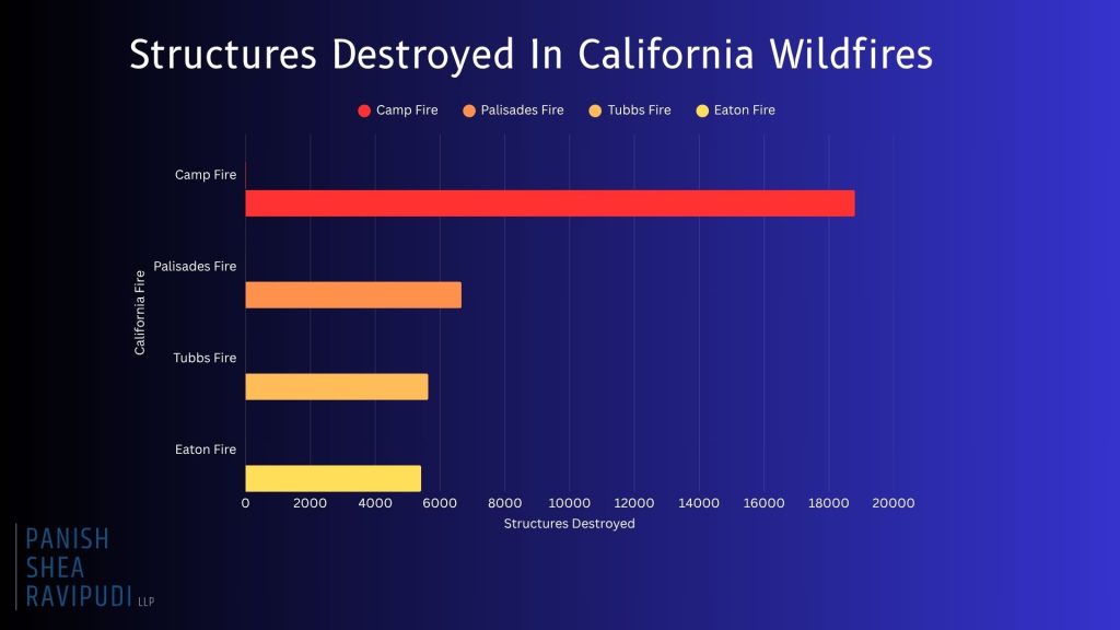
- Camp Fire (November 2018) 18,804 structures destroyed.
- Palisades Fire (January 2025) 6,662 structures destroyed.
- Tubbs Fire: (October 2017) 5,636 structures destroyed.
- Eaton Fire: (January 2025) 5,418 structures destroyed.
Every year, California is confronted with more destructive, record-breaking fires that redefine the danger of California wildfires and demonstrate the dire circumstances many Californians live under.
California Counties Most At-Risk From Wildfires
Currently, more than 2.3 million acres of land in California are considered to be “high” or “very high” risk areas for wildfires, with a handful of California counties containing many of these acres within their borders.
Riverside County
- Based on Cal Fire’s Fire Hazard Severity Zone maps, large portions of Riverside County are rated as “Very High” for wildfire risk. This is increased in regions such as the San Bernardino National Forest, Santa Ana Mountains, and areas around Palm Springs and Temecula.
- FEMA ranks Riverside County as one of the highest-risk areas for wildfires in California, giving it a maximum risk score of 100%. The county is projected to lose an estimated $319 million each year due to wildfires.
- Over 70% of structures in Riverside County are at risk of wildfire damage.
- With an ever-growing population of more than 2.5 million, the risk of wildfires in Riverside County remains a constant danger to the populous.
San Diego County
- According to updated CAL FIRE maps, San Diego County has seen a 26% increase in areas classified as “Very High Fire Hazard Severity Zones,” growing from about 647,000 to over 871,000 acres. What’s especially concerning is that more urban neighborhoods are now falling within these high-risk zones.
- Many communities are situated in the Wildland-Urban Interface, where development meets undeveloped wildland, increasing the potential for property damage and loss to wildfires.
- Several San Diego County cities, including Chula Vista, Del Mar, Carlsbad, Poway, Santee, and San Marcos, have experienced a 10% minimum increase in areas classified as “Very High Fire Hazard.” Poway, in particular, now has nearly 80% of its total land area designated within this most severe fire risk zone.
San Bernardino County
- With a population exceeding 2 million, many residents live in areas classified under high to very high fire hazard severity zones.
- Urbanization has led to previously undeveloped high-risk regions being populated, increasing the number of homes and structures at risk.
- Many cities such as Big Bear Lake, Chino Hills, Colton, Fontana, Hesperia, Rancho Cucamonga, Redlands, Rialto, San Bernardino, Upland, and Yucaipa fall within the very high fire hazard severity zone.
- Approximately 53% of buildings in San Bernardino are at risk of wildfire, with a high-risk level.
- San Bernardino experiences increased drought conditions, contributing to heightened wildfire potential.
Los Angeles County
- In March 2025, CAL FIRE’s updated maps designate extensive areas in Los Angeles County as “Very High Fire Hazard Severity Zones including cities such as Los Angeles, Malibu, Pasadena, Santa Clarita, and Glendale.
- Los Angeles’ “Very High Fire Hazard Severity Zones” expanded from 646,838 acres in 2011 to 817,212 acres in 2025.
- Urban expansion into grasslands and timberlands has increased the population now living in the Wildland-Urban Interface (WUI) hazard areas.
- Areas where wind-blown embers can ignite distant structures now affect approximately 1.3 million structures in Los Angeles County.
Ventura County
- 88,000 acres in Ventura County fall into the “very high” fire hazard category, a 54% increase from previous years.
- Many communities in Ventura County are located where urban neighborhoods meet wildland areas, which raises the risk of wildfires threatening homes and critical infrastructure.
- Almost 80% of buildings in Ventura are vulnerable to wildfires, with a large number falling within high-risk zones.
- Extended dry periods and below-average rainfall have created perfect conditions for wildfires, turning Ventura County’s fire season almost a year-round risk.
Runner-Up: Orange County
- Extra high-risk areas include Eastern OC, including Trabuco Canyon, Silverado Canyon, Modjeska Canyon, and parts of Anaheim Hills and Yorba Linda.
- Large portions are rated “Very High Fire Hazard Severity Zone.”
- Many homes border undeveloped wildland, increasing the risk of uncontrollable fires.
- Dry, fast Santa Ana winds fuel rapid wildfire spread in fall and winter.
- With over 3 million residents, there is growing development in fire-prone areas with high property values, increasing potential wildfire-related losses.
Steps to Take if You Live in a High-Risk Wildfire Area
If you live in an at-risk area for a wildfire, as many Californians do, there are still precautions and actions you can take in the event of a wildfire in your area.
Before a Wildfire
- Regularly clean roofs, gutters, decks, and patios of leaves, pine needles, and other flammable debris.
- Store gasoline and other flammables in approved containers away from the structure.
- Attach garden hoses long enough to reach all areas of your property.
- Keep firefighting tools accessible.
- Review and update your insurance policies.
- Videotape your home and possessions periodically for insurance documentation purposes.
- Create and practice a wildfire evacuation plan, including routes and safety procedures.
- Keep essential personal items (e.g., passports, birth certificates, photographs, valuable jewelry) in an easy-to-access location.
- Build and store accessible emergency supply kits for each member of the household.
- Remove flammable vegetation and materials within at least 30 feet of your home.
During a Wildfire
- Stay informed on evacuation orders and the direction of the fire.
- Gather all essential belongings and emergency kits in preparation for evacuation.
- Follow a pre-planned evacuation route.
- Listen and follow the directions of first responders.
- Be prepared to either drive or evacuate on foot.
- Secure all pets.
- Remain calm.
After a Wildfire
- Only return home when authorities say it’s safe.
- Inspect your property for structural damage, gas leaks, and electrical issues.
- Watch for hotspots, ash pits, or weakened trees and structures.
- Report the damage and start the claims process as soon as possible.
- Speak to a California wildfire attorney.